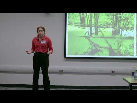
This research investigates methane emissions from restored marshes as a climate solution. While marshes sequester CO₂, their methane output varies widely. By measuring emissions and environmental factors, the study examines how interactions influence outcomes, highlighting that restoration can aid climate mitigation but requires deeper understanding to ensure effectiveness.
2026
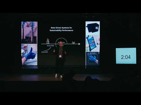
This research develops data-driven systems to help organizations measure and reduce their environmental impact. Using low-cost sensors and digital tracking tools, the work enables companies and hospitals to better understand emissions and resource use. Case studies show significant reductions in carbon emissions and disposable glove usage through practical design science solutions.

This study examines whether burned area from forest fires in Portugal can be predicted using satellite, weather, and time-series data. Results show human-caused fires dominate over natural ones, and predictive models achieved around 95% accuracy, demonstrating strong potential for improving resource allocation and fire management strategies.

This study evaluated multispectral and hyperspectral vegetation indices to estimate wildfire severity in the 2022 Sierra de la Culebra fire. Field Composite Burn Index data were correlated with satellite-derived indices. Results showed hyperspectral imagery provided more accurate severity estimates, particularly using Cellulose Absorption Index and Red Edge indices.
2026
This study explored whether satellite remote sensing can estimate black truffle mycelium biomass. Optical vegetation indices showed limited results, while Sentinel-1 radar backscatter had significant correlations, especially in spring. Findings suggest radar data capture soil moisture dynamics linked to fungal activity, offering a promising tool for sustainable truffle orchard management.

2026
This study developed a real-time IoT-based system to optimize fishway performance in fragmented rivers. Using sensors, PIT-tag tracking, and machine-learning models, it links climate triggers with hydraulic controls. Adaptive sluice-gate regulation improved fish passage efficiency by 166% without reducing hydropower output, offering scalable, sustainable river management.
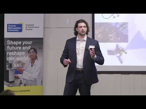
The speaker explains how hyperspectral satellites can detect invisible methane emissions, a major driver of climate change. Their research integrates data from multiple satellites to create a continuous global monitoring system capable of identifying leaks in real time, enabling rapid mitigation and transforming satellite technology into a tool for planetary sustainability.

Bur Oak Blight threatens Iowa’s most iconic tree. Current detection is slow and often too late. This research uses leaf-level reflectance and satellite imagery to identify early, invisible signs of infection across millions of trees. The approach enables rapid mapping of blight severity and helps protect Iowa’s ecological and cultural heritage.
2025
Sunny-day flooding is becoming common in coastal North Carolina. Sensors revealed 65 flood days per year, and water-quality tests showed fecal contamination up to 100× above closure standards. A new computer model tracks how contaminated floodwaters move, helping identify hotspots and supporting safer water-quality advisories and flood-defense planning.

My research uses artificial intelligence to detect water pollution by analysing DNA traces left by aquatic species. Instead of relying on visual signs or costly expert identification, supervised machine learning reads species patterns to determine water quality. The method is faster, cheaper, and more accurate than traditional analysis.